After a delicious fish and chip lunch in Depoe Bay, Oregon, we headed back south towards Newport, with a stop at Cape Foulweather, one of the most popular and picturesque areas along the Oregon Coast. To access Cape Foulweather you exit Highway 101 at Otter Crest Loop.
Ben Jones Bridge on Otter Crest Loop
We crossed over and then stopped at Ben Jones Bridge. At the bridge there are amazing views of the back of the Cape Foulweather visitors lookout and Rocky Creek Falls. This loop climbs up to the top of the cape where you can visit the lookout.
The visitor's center lookout looks so small from the Ben Jones Bridge
Rocky Creek Falls
Rising 500 feet above the ocean, Cape Foulweather is “where Oregon began.” It’s the first Oregon land formation that Captain Cook spied in March, 1778. Cook coined the name for the fierce weather and rough ocean conditions that he and his crew encountered.
Top of the cape
Cape Foulweather Gift Store’s history reaches back nearly a century when Buck and Ann Badley built the place as a coffee shop. They named it ‘Fairweather Coffee Shop,’ but they found out that wasn’t really what the visitors wanted. Folks wanted souvenirs that they could take back with them, so the Badley’s changed it into a gift store.
Top of the cape with the visitors center in view
Oregon State Parks acquired the site in 2013 and quickly made changes. OSP opened up the store’s space to give visitors more opportunity to enjoy the views. They cleared shelves away from the windows and put in benches and binoculars to invite people to stay longer.
Below the cape
View from the top of the cape, old stone rock wall keeps you from falling off
View to the south from the cape
Unfortunately, because it was a Sunday, the visitors center was closed but that didn't stop us from taking in the view!
We found this video from Gran't Getaways that tells all about beautiful Cape Foulweather!
The next leg of our journey took us from Newport to Florence, Oregon, with many stops along the way!
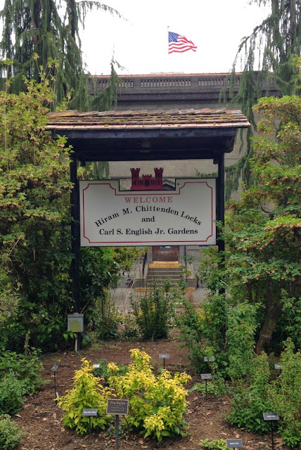
Leaving Pike Place Market we headed to the neighborhood of Ballard . Ballard is located in the northwestern part of Seattle. To the north it is bounded by Crown Hill, (N.W. 85th Street); to the east by Greenwood, Phinney Ridge and Fremont (along 8th Avenue N.W.); to the south by the Lake Washington Ship Canal; and to the west by Puget Sound’s Shilshole Bay. The neighborhood’s landmarks include the Hiram M. Chittenden Locks (known locally as the "Ballard Locks"), the Nordic Heritage Museum, the Shilshole Bay Marina, and Golden Gardens Park. Entrance to Carl S. English Jr. Botanical Gardens and Hiram M. Chittenden Locks The Hiram M. Chittenden Locks, or Ballard Locks, is a complex of locks at the west end of Salmon Bay, in Seattle, Washington's Lake Washington Ship Canal, between the neighborhoods of Ballard to the north and Magnolia to the south. We wanted to know and followed the fish but didn't realize it was across the locks until we were on our way
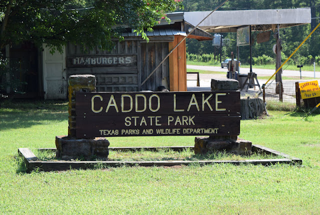
While visiting the historic town of Jefferson we could not pass up the opportunity to make a short visit to Caddo Lake State Park . The park sits near the small town of Karnack, in east Texas. The name of this park is a bit deceiving as the park doesn't sit on the shores of Caddo Lake (the only natural, fresh water lake in Texas) but on Big Cypress Bayou. Entrance sign Entrance signs to Caddo Lake State Park Big Cypress Bayou from boat ramp (west) Big Cypress Bayou looking east. Follow the bayou east to reach Caddo Lake. Like most Texas state parks the structures within Caddo Lake SP were built by the Civilian Conservation Corps . Company 889 began the work, in June to November of 1933. Company 857 continued construction from October 1934 to March 1937. One of the cabins that can be rented at the park CCC workers converted 15 U.S. Army barracks and an Army mess hall into the nine log cabins and group recreation hall that can be used today.
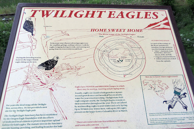
Sadly, we left Astoria and traveled east on the East Columbia Highway (Highway 30) back to Portland to catch the red eye back home. When we passed the sign, we knew we had found what our trip had been missing so we turned the Blue Devil around and headed to the Twilight Eagle Sanctuary. The Twilight Eagle Sanctuary is located within Cathlamet Bay , 2.5 miles east of Astoria, Oregon , and just downstream from Settler Point. This wetland Sanctuary was established in 1992, and along with Columbia Land Trust acquisitions in 2009, now totals over 100 acres of old growth forest, tidal wetlands, and shoreline, and stretches nearly a mile along the Columbia River. The Sanctuary is just off of U.S. Highway 30. A viewing platform overlooks acres of mudflats, tidal marshes, open water, and islands. It is an excellent location to observe birds and other wildlife living on the lower Columbia River estuary. The viewing area has several interpretive panels about the wetlands, bald eagles,